
Trail Running App for Apple Watch
Custom Trail Running screens on Apple Watch, live with GPS, heart rate, and your real zones.
Off the grid, the map widget keeps drawing your route from offline tiles and the watch falls back to bundled terrain when the phone is out of reach. Track climb, cadence, and zones where there is no signal at all.
Load a GPX of the trail before you leave, and the watch draws the track under your live breadcrumb, buzzes when you drift off it, and announces waypoints as you reach them. No subscription tier, no region purchase, no account, the whole navigation stack ships with the app.
Everything a trail asks of a screen is a widget: remaining ascent, the elevation profile of the next kilometres, live grade, or simply a huge map with your position on it.
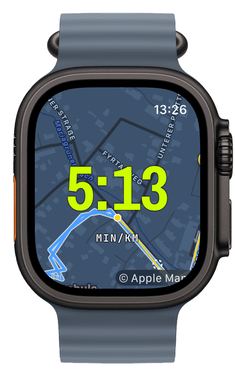
Maps that work where there is no signal
Offline maps are prepared on the iPhone: frame the region you are heading into, pick the zoom levels you want, and Runara exports the tiles into a bundle that syncs to the watch, with delivery status you can actually see. On the trail, the map background and map widget fall back to those tiles automatically the moment the network drops, and a manual offline switch always wins if you want certainty before you start.
The watch renders those tiles with its own map engine, so panning, Digital-Crown zoom, and recentring keep working in airplane mode, deep in a valley, or with the phone at the trailhead.
Navigation built for trails
Import a GPX on the iPhone, or turn any past run into a route, and the track appears as a blue line under your yellow breadcrumb on every map surface, online or offline. Waypoints come along too, up to fifty per route, each one announced with a buzz and, if you want, a spoken name as you arrive.
Drift off the line and the watch tells you, a haptic always, a spoken “Off route” if you enable it, with the detection debounced against GPS noise so a tight switchback does not set off false alarms. A dashed pointer on the map shows the shortest way back to the track. It is honest, geometric navigation, there is no turn-by-turn, and it never needs a connection.
The route progress widget keeps the long view: distance remaining, percent complete, and, crucially for trails, the ascent still ahead of you. The elevation profile widget shows the shape of what is coming, including a next-kilometres view for reading the climb you are actually in.
How a trail run is recorded
Under the map, the recording works like every Runara foot sport: GPS at the accuracy tier you choose, continuous heart rate against your five real zones, cadence in steps per minute, and live ascent, descent, and grade. Pace smoothing over 5 to 30 seconds keeps erratic trail pace readable.
The finished run is written to Apple Health as a complete workout with the full route. One honest detail: Apple Health categorises it as a Running workout, that is how Apple’s outdoor-run type works, while Runara keeps trail runs as their own sport in history, achievements, and screens.
- Offline map & trail
- Your position and breadcrumb on tiles stored on the watch itself, with the route track drawn underneath. Pan, zoom with the Digital Crown, recentre, all without a connection.
- Elevation & climb
- Live ascent, descent, and grade while you run, a height diagram of the run so far, and the route’s elevation profile with your position moving along it.
- Route progress
- Distance remaining, percent complete, and the ascent still ahead, the number that decides how you ration your legs on a long trail.
- Cadence
- Steps per minute from the watch’s motion sensors, useful on terrain where pace lies and rhythm tells the truth.
- Heart rate & zones
- Five zones anchored on your real data, live as badge, bar, or ring, with a zone-coloured diagram afterwards. On climbs, effort is the only honest pace.
- Pace, smoothed
- Trail pace jumps with every root and rock. A rolling 5 to 30 second smoothing window turns it into a number you can actually pace by.
Our pick of watch screens for this sport — designed in the Runara screen designer, ready to run on your wrist.
Type the code into the Runara app to import the set, or customize a copy in the designer and share your own.
Auto Pause
Runs, rides, walks and hikes pause themselves when you stop and resume the moment you move again, tuned per sport, on by default.
→Readiness & HRV
Readiness weighs your HRV and resting heart rate from Apple Health against your own baseline, and Apple Watch Series 12 and Ultra 4 feed it far more HRV than any watch before.
→Offline Maps
Save a map area on iPhone and your Apple Watch shows it anywhere, with no signal and no phone.
→GPX Routes & Navigation
Import GPX routes on iPhone and follow them on the watch, with off-route alerts, waypoints, and a live elevation profile.
→3D Flyover
A chase camera flies your recorded route over 3D terrain and exports a share-ready video, right on the iPhone.
→Live Weather
Seven environment widgets put live weather and altitude into any workout-screen slot, fetched by the watch itself.
→Virtual Pacer
Pick a route and a target pace, and a ghost runs it with you — the pacer widget shows exactly how far ahead or behind you are.
→Live Workout Display
Your configured screens render on Apple Watch with real-time metrics, GPS, and haptics, legible at a glance under load.
→Heart-Rate Zones
Zones anchored on your actual resting and peak HR, with a colour-blind-safe band you can read at speed.
→Workout History & Splits
Browse every saved workout with route maps, per-segment splits, and full metric detail.
→Achievements
A trophy room of eighty achievements across sixteen workout types, with engraved cups and a celebrating parrot.
→Do the offline maps work without the iPhone and without any signal?
Yes. The map tiles are stored on the watch itself, synced from the iPhone before you leave. On the trail the map keeps rendering with no phone nearby and no network at all, and an offline switch lets you force it even when there is coverage.
Can I follow a GPX trail on the Apple Watch with Runara?
Yes. Open a GPX from Mail, Files, or Safari in Runara on the iPhone and it syncs to the watch. When you start a trail run, you pick the route, and the track draws under your breadcrumb with waypoints, progress, and the elevation profile, no subscription and no account.
Does Runara warn me when I take a wrong turn?
Yes. When you drift off the route the watch buzzes, optionally says “Off route”, and draws a dashed pointer back to the track; when you rejoin, it confirms that too. Detection is debounced against GPS noise, so switchbacks and tree cover do not cause false alarms. It is geometric guidance, not turn-by-turn.
Does Runara show climb and grade while I run?
Yes, ascent, descent, and current grade are live widgets, and with a route chosen you also see the ascent remaining and the profile of the next kilometres. After the run, the iPhone detail view shows the full elevation diagram alongside heart rate and pace.
Do I need an Apple Watch Ultra for trail running?
No. Runara runs on any Apple Watch with watchOS 26 or later, the offline maps, GPX routes, and navigation alerts are the same on every model. A bigger battery buys longer days out, and on an Ultra, Ultra 4 included, the Action button can start a new segment or pause the run without looking, but no tracking feature is gated to the Ultra.
Track Trail Running your way
Runara turns your Apple Watch into a custom Trail Running computer. Native and private, free for your first three workouts, then one purchase unlocks everything, no account, no subscription.