
Hiking App for Apple Watch
Custom Hiking screens on Apple Watch, live with GPS, heart rate, and your real zones.
For long days out, lean on offline maps and elevation tracking. Your full route is recorded into Apple Health, climb and all, with the map drawing even deep in a valley.
There is no premium tier hiding the useful parts: offline maps, GPX routes, waypoints, and off-route alerts all ship with the app, with no account behind them. Sync the region and the route at home, then leave the phone in the pack, or at home entirely.
Waypoints make long routes humane. Mark the spring, the fork, the hut, and the watch buzzes and announces each one as you arrive, while the route progress widget keeps the two numbers that matter in view: distance left, and climb left.
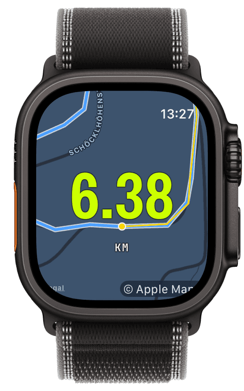
Offline maps without a subscription
Before the hike, frame the region on the iPhone’s Maps tab, choose the zoom detail, and export the tiles into a bundle that syncs to the watch with visible delivery status. On the mountain, the map background and map widget switch to those tiles automatically when coverage drops, or stay offline from the first step with a manual switch.
The watch draws the map with its own renderer, pan, zoom with the Digital Crown, recentre, so navigation does not depend on the phone being reachable or on any network existing at all. There is no Pro unlock and no per-region purchase: preparing offline regions is simply part of the app.
Routes, waypoints, and the climb ahead
Import the GPX of the tour, from Mail, Files, or Safari, and it syncs to the watch with its waypoints, up to fifty of them. Out on the trail the track runs as a blue line under your breadcrumb; drift off it and the watch buzzes and points you back, reach a waypoint and it tells you which one.
The elevation story runs the whole day: live ascent, descent, and grade while you climb, the route’s profile with your position on it, remaining ascent in the progress widget, and a total-ascent row on the summary when you finish. Back home, the iPhone shows the full elevation diagram next to heart rate and pace.
Any hike can become next year’s route: Save as route turns the recorded track into a followable line, and Share GPX exports it, elevation and timestamps included, to wherever you plan.
A full day in Apple Health
A hike saves as a Hiking workout with the complete route, heart rate, steps, and energy, one clean entry that Apple Health, Apple Fitness, and any app you allow can read. Runara keeps no copy anywhere else; a GPS accuracy tier of Balanced or Battery saver stretches the watch through long days without changing what gets recorded.
- Offline map
- Map tiles stored on the watch, prepared per region on the iPhone. Pan, zoom, and recentre with zero connectivity, no Pro tier, no region purchases.
- Elevation & climb
- Live ascent, descent, and grade, the route’s elevation profile with your position, and total ascent on the finish summary.
- Route progress & waypoints
- Distance remaining, percent complete, remaining ascent, and up to fifty waypoints per route, each announced on arrival.
- Heart rate
- Continuous heart rate across the whole day, with zones if you hike for training and a plain number if you hike for the view.
- Distance & steps
- GPS distance and the day’s step count, both written into the Apple Health workout.
- GPS route
- The complete track, drawn live and saved with the workout, ready to become a followable route or a shared GPX afterwards.
Our pick of watch screens for this sport — designed in the Runara screen designer, ready to run on your wrist.
Type the code into the Runara app to import the set, or customize a copy in the designer and share your own.
Auto Pause
Runs, rides, walks and hikes pause themselves when you stop and resume the moment you move again, tuned per sport, on by default.
→Offline Maps
Save a map area on iPhone and your Apple Watch shows it anywhere, with no signal and no phone.
→GPX Routes & Navigation
Import GPX routes on iPhone and follow them on the watch, with off-route alerts, waypoints, and a live elevation profile.
→3D Flyover
A chase camera flies your recorded route over 3D terrain and exports a share-ready video, right on the iPhone.
→Live Workout Display
Your configured screens render on Apple Watch with real-time metrics, GPS, and haptics, legible at a glance under load.
→Live Weather
Seven environment widgets put live weather and altitude into any workout-screen slot, fetched by the watch itself.
→Workout History & Splits
Browse every saved workout with route maps, per-segment splits, and full metric detail.
→Achievements
A trophy room of eighty achievements across sixteen workout types, with engraved cups and a celebrating parrot.
→Can I hike with the Apple Watch and leave the phone at home?
Yes, once the offline region and the route are synced, the watch carries the whole day alone: map, track, waypoints, off-route alerts, heart rate, and the recording itself. The phone is only needed beforehand, to prepare maps and routes, and afterwards, if you want the big-screen review.
Do the maps really work with no coverage at all?
Yes. The tiles live on the watch, and the watch renders them itself, so a dead valley, airplane mode, or a phone in the car changes nothing. If you want certainty, flip the offline switch before you start and the map never even tries the network.
Does Runara show elevation gain, and how trustworthy is it?
Ascent, descent, and grade are live on the watch, the summary shows total ascent, and the iPhone detail view draws the full elevation diagram. The numbers come from the watch’s own sensor data recorded during the hike, so they reflect what you actually climbed rather than a map’s estimate of the trail.
Can I follow a GPX hiking route with waypoints?
Yes. Open the GPX in Runara on the iPhone, waypoints import with it, up to fifty, and the watch follows the track offline, announces each waypoint on arrival, and warns you if you leave the route. There is no turn-by-turn, the guidance is the drawn track plus alerts, which is exactly what marked trails need.
Is any of this behind a subscription?
No. Offline maps, GPX import, waypoints, and navigation alerts are all part of the app, with no account and no Pro tier. Runara also sends nothing to a server, the maps, routes, and your hikes stay on your devices.
Will the workout pause when I stop to look at something?
Yes, auto pause is on by default for walks and hikes. It is tuned for walking speeds, so a slow stroll keeps recording while a real stop of about four seconds pauses the clock, and it resumes once you walk on. Switch it off per sport in the iPhone settings if you prefer to count every minute.
Track Hiking your way
Runara turns your Apple Watch into a custom Hiking computer. Native and private, free for your first three workouts, then one purchase unlocks everything, no account, no subscription.